

The division between ‘Highlands’ and ‘Lowlands’ is so essential to most peoples’ understanding of Scotland that we rarely dwell on what those terms really mean. It is tempting to focus on the cultural differences – the exuberance of Highland hospitality versus the alleged, relative coldness of Lowland city-dwellers; accusations from medieval Lowland scribes about the misdeeds of “wyld, wikked Heilan’ men” versus the derisive insults of Highlanders against “soft Southrons”; and the predominance of Gaelic in the Highlands and of Scots and English in the Lowlands.
Yet, what fundamentally makes the Highlands the Highlands and the Lowlands the Lowlands is far more primordial and elemental than all that. What really defines them, both in their own right and relative to the other, lay in the very land itself. A closer look leads to plenty of assumption-shattering surprises.
One of the best ways to understand the Highlands and Lowlands is to look at a map of Scotland which shows terrain features, such as an Ordnance Survey map or Google Maps on your phone or computer with terrain enabled. At first glance, what you see appears to confirm expectations: the Highlands are the hilly regions in the north, and the Lowlands are the flatter regions in the south. Simple, right? Not so fast. Look as far north as you can go on the Scottish mainland and you’ll arrive in Caithness, where flat peatlands and fertile fields have nary a hill in sight. Now, look as far south as you can go to the Borders, where the Lammermuir and Cheviot Hills rise up as rugged and daunting to the traveller as most any Highland glen. Look to the west coast and then to the east. On the same latitude as the iconically-mountainous Isle of Skye are the mellow breadbaskets of Moray and Buchan, where – purely in terms of the landscape – you’d be forgiven for thinking you had somehow stumbled several hundred miles south into England.
The Highland Boundary Fault
From a geological standpoint, there is a dividing line – the Highland Boundary Fault. This tectonic fault line runs from the Isle of Arran in the southwest to just shy of Stonehaven in the northeast. It’s stunningly obvious on a map. Look north of Glasgow, Stirling, Perth, and Dundee, and the land to the north of those cities quickly rises up and crinkles with contour lines. But, as we’ve seen with the above examples, it’s not as simple as everything north of that line being the Highlands and everything south of it being the Lowlands. There are Lowland-style landscapes within the Highlands and Highland-style landscapes within the Lowlands. Geologically, Highlands are generally in the north and the west, and Lowlands are generally in the south and the east. Just look at how the Cairngorms extend almost all the way to the sea in the east, only to cut back north and west leaving a Lowland-style fertile strip all along the coast.
Highlands and Lowlands are not just defined by where a parcel of land is located. Even more crucial is how that land is used, and what types of historical communities it fosters. Huge swathes of the Highlands have elevations higher than 1,000ft above sea level, the point at which crops are less capable of growing even in optimal conditions. Highland soils tend to be more acidic and thinner than Lowland soils, often barely covering the underlying stone which, in some areas, is the oldest exposed stone in the world, exposed by millennia of wind, rain, and glaciation. Wind and rain especially scour the higher grounds, creating conditions wholly unfavourable to most crops and even to many trees.
The nature of the soil
This, in turn, means that fewer intensive crops can be cultivated in Highland areas, which reduces the likelihood of abundance and therefore of stable surpluses and population growth. The nature of the soil is why Highland societies from the Neolithic right up to today are more reliant on pastoralism – mostly with cattle, and in more recent centuries with sheep – than on agriculture, though there are of course localised exceptions.
Pastoral societies rarely develop large, concentrated population centres, and instead tend to have more spread-out, low-density settlements. The population of the Highlands was in fact equivalent to that of the Lowlands until the 18th century, but rather than clustering in towns and cities the Highlanders were in countless small farmsteads scattered all around the glen floors and lower slopes. The lone city in the Highlands, Inverness, is immediately next to the incredibly fertile region of Moray and could not have grown beyond a township without it. Otherwise, the Highlands have no cities and very few towns anything like even a mid-sized town in the Lowlands. The kin-based clan system is a natural unit of social organisation in such conditions. Equivalents can be found among historical tribal groups in Scandinavia, indigenous America, and Afghanistan. In the Lowlands, by contrast, there is much more scope for interactions with people not from your immediate community and outwith your kin group. Such places tend to develop more complicated social hierarchies and relationships, with many strangers wittingly or unwittingly involved in the production of goods and development of institutions. In the Highlands, by contrast, a stranger was known as one on sight, such was the tightness of the pastoral societies in the days before mass transport and globalisation.
Contrast this with the Lowlands, where pastoralism existed alongside widespread intensive agriculture capable of producing, in the good times at least, enough of a surplus to support specialist trades and urban growth. The relative predictability of agricultural yields and resultant capacity for growth could sustain booming populations (to a point) and serve as the basis for more decentralised forms of social power. This is part of the reason why feudalism became entrenched in the Lowlands while it largely failed to take root in the same way in the Highlands.
Understanding the Highlands and Lowlands
All these factors determining what the land is capable of supporting are far more important to understanding the Highlands and Lowlands than simply how far north, south, east, or west the land is. They are certainly more important for understanding the types of communities that grow within them. For the vast majority of history, a farmer in Aberdeenshire, for example, had much more in common with a fellow farmer in Midlothian or Ayrshire many miles to the south than with a Highlander much closer to home in the Cairngorms or Highland Perthshire. Someone from the Isle of Lewis would have instantly recognised the basic flow of life for a drover or crofter in Argyll or even the hillier regions of Dumfries & Galloway, while the ways of town-dwellers in Stirling or Peebles would have been quite alien.
So, what makes the Highlands and the Lowlands? Of course it’s the people, the history, and the culture – but none of things would be what they are if the land beneath them all were different. In many ways, the stories of the Highlands and Lowlands were written many years before there were people to tell them.
Text by: David C. Weinczok
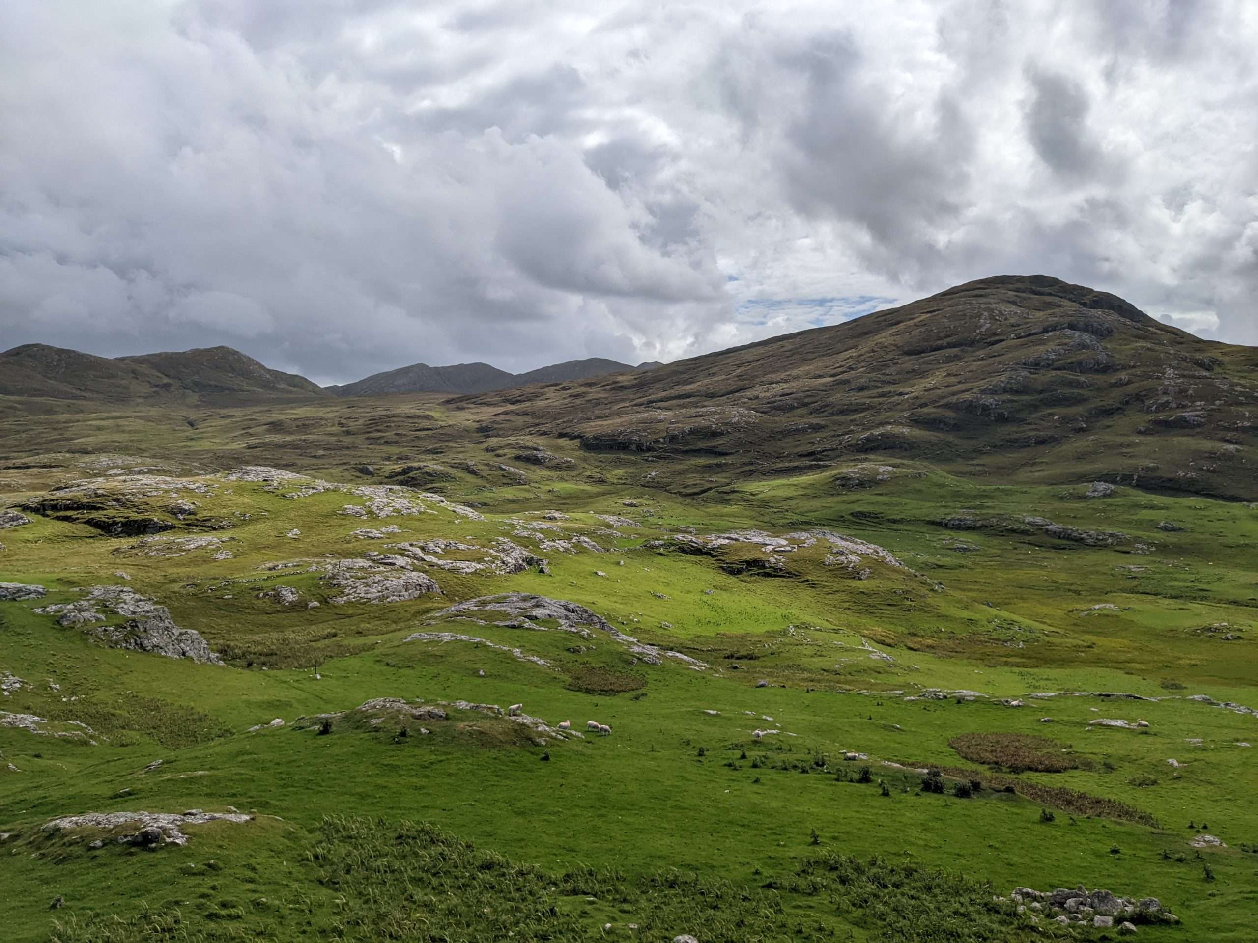
Main photo: Kilmartin Glen, Argyll, where a fertile valley floor gives way to thin, peated upland soils which defined settlement patterns since the Mesolithic period.