
Orkney is a place of innumerable wonders great and small. Most visitors tend to gravitate towards a handful of well-known sites like Skara Brae, Scapa Flow, and the Broch of Gurness. Across the archipelago, however, are historic sites and natural landscapes of staggering variety and character which relatively few tend to tread. These are a few of my favourites, all freshly visited during a month-long stay in February 2025.
The Brough of Birsay
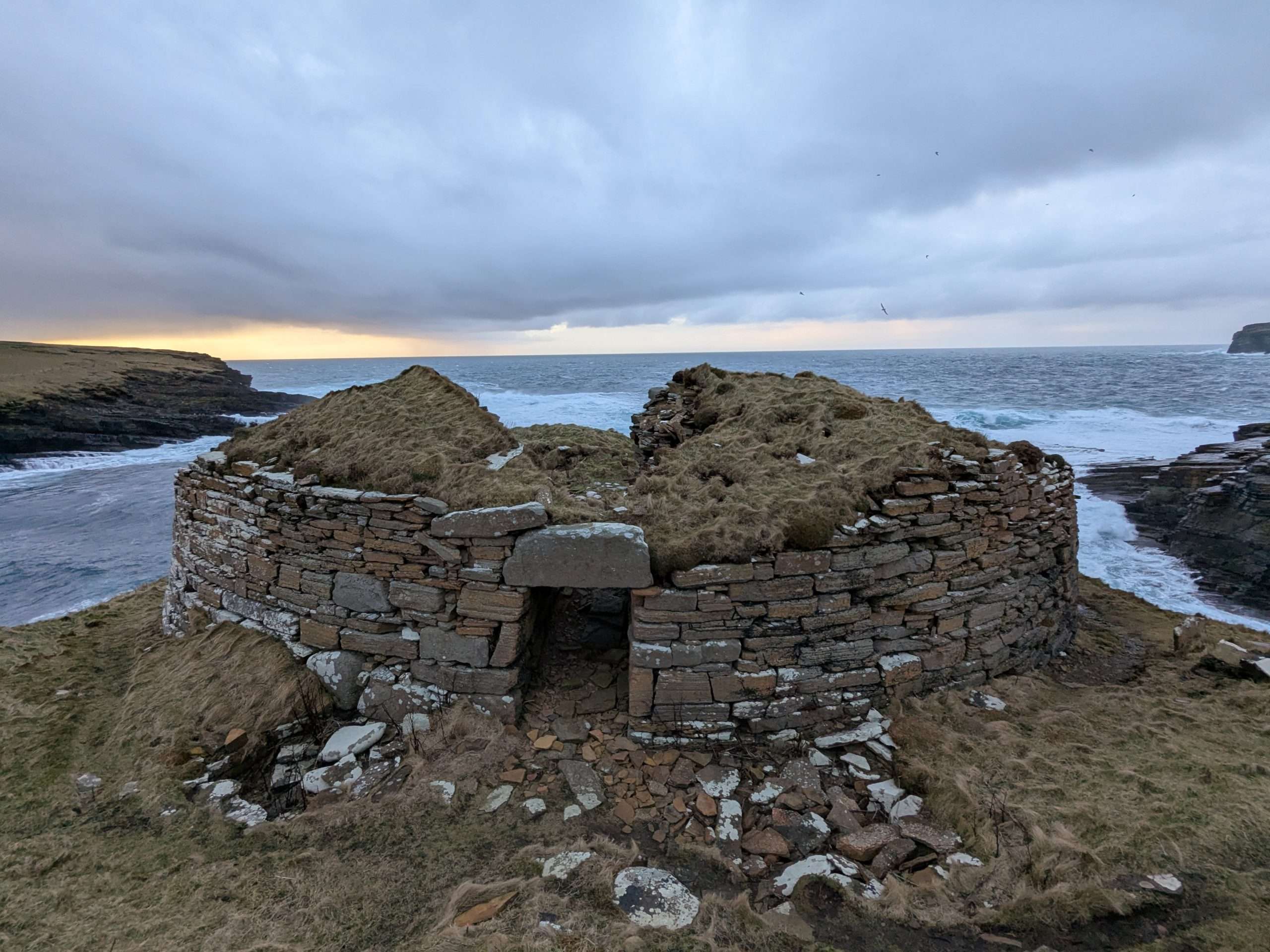
The Brough of Birsay is a very special place, cherished by Picts, Norse, and modern Orcadians alike. Sloped like a cresting wave with towering cliffs on its seaward face, the Brough of Birsay is an island only accessible at low tide by a meandering causeway traversing a wonderland of tidepools and rock formations.
A large Pictish settlement was established on the island, later superseded by a Norse settlement which was possibly the base of operations for Thorfinn the Mighty, a mighty Norwegian Earl of Orkney. It is holy, too – pilgrims make their way to the Brough of Birsay to pay tribute to St Magnus, whose body was possibly taken here after his murder-cum-martyrdom on the island of Egilsay. George Mackay Brown, Orkney’s quintessential writer, set many stories and plays on the island and along its sea-swept causeway.
Built heritage aside, the Brough of Birsay is a prime puffin-spotting location in May and June and affords spectacular views across Birsay Bay to the south and to Westray to the north. On my recent visit I took great pleasure in wandering the island’s fringes, searching for seashells among the tidepools, and contemplating the countless generations and multiple cultures who invested the Brough of Birsay with an air of both secular and spiritual reverence.
North Ronaldsay Lighthouse and seaweed-eating sheep
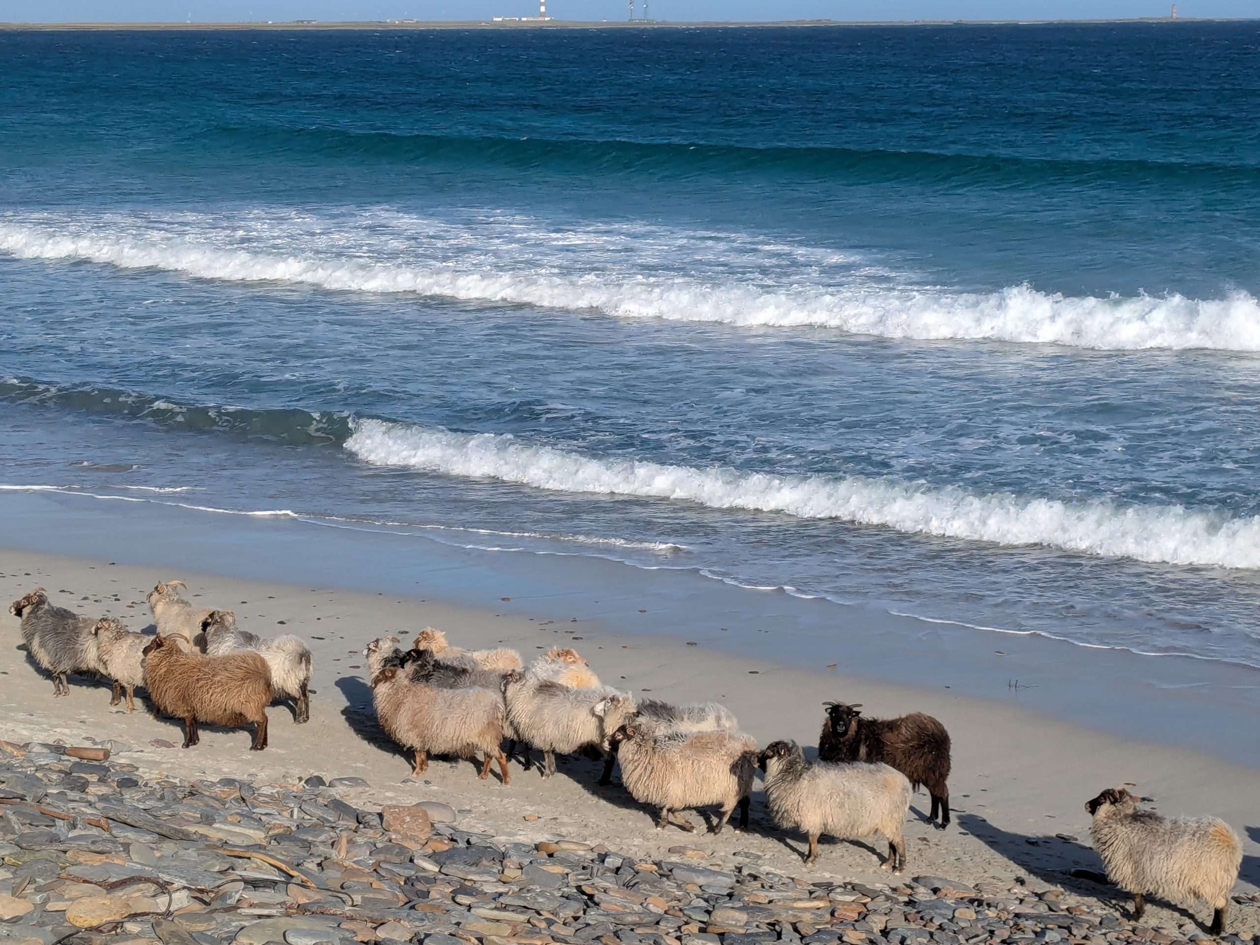
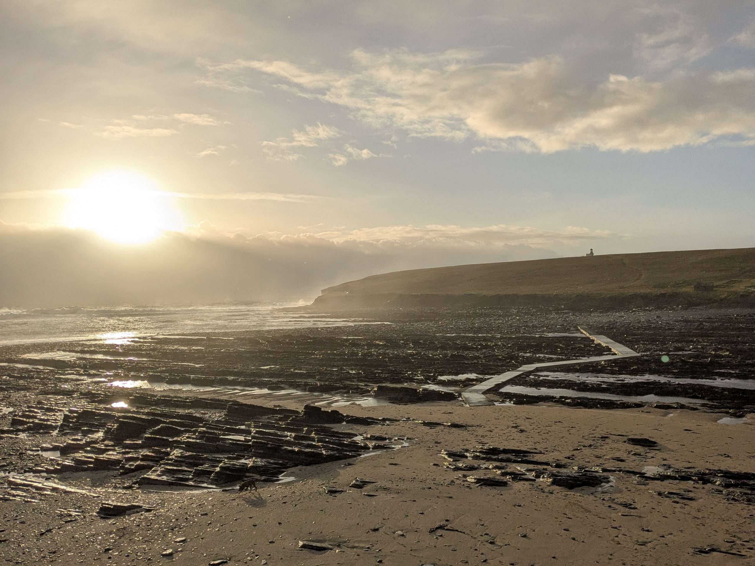
North Ronaldsay is the northernmost of the Orkney Islands, reachable by a 2.5-hour ferry from Kirkwall or, in my case, a spectacular 15-minute flight in an eight-seater propeller plane. The island’s fertile inland contrasts with a precipitous and rugged coastline, and it is along this coastline that you will find North Ronaldsay’s most numerous and distinctive residents – beach sheep
The North Ronaldsay breed is unique in subsisting on foraged seaweed. Their sure-footedness on the stones is unmatched, and they resemble the ancient sheep breeds which prehistoric Scots would have farmed. They’re not fazed by much, sometimes even approaching human observers and mingling with basking seals. The whole island is encircled by a Grade A-listed Sheep Dyke, a stone wall first built in the 19th century which keeps the sheep on the shore and has pens for shearing them. Much of their wool is processed in the historic North Ronaldsay Lighthouse, the tallest land-based lighthouse in the UK at 42 metres high. It was built in 1852 by Alan Stevenson, a member of the renowned ‘Lighthouse Stevensons’ family. The lighthouse has a visitor centre with guided climbs up its 176 steps, atop which you can easily see Fair Isle and sometimes even Shetland on a clear day. Within easy sight of the newer lighthouse is the Old Beacon, the third lighthouse built in Scotland first lit in 1789 and now abandoned.
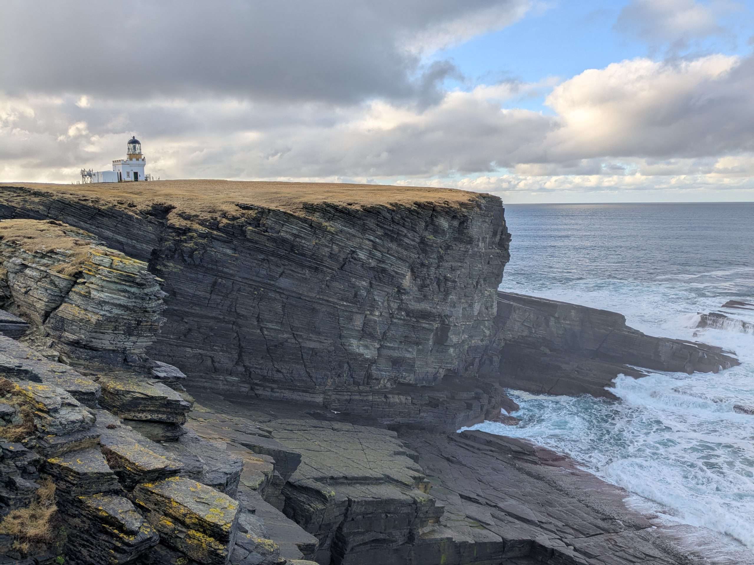
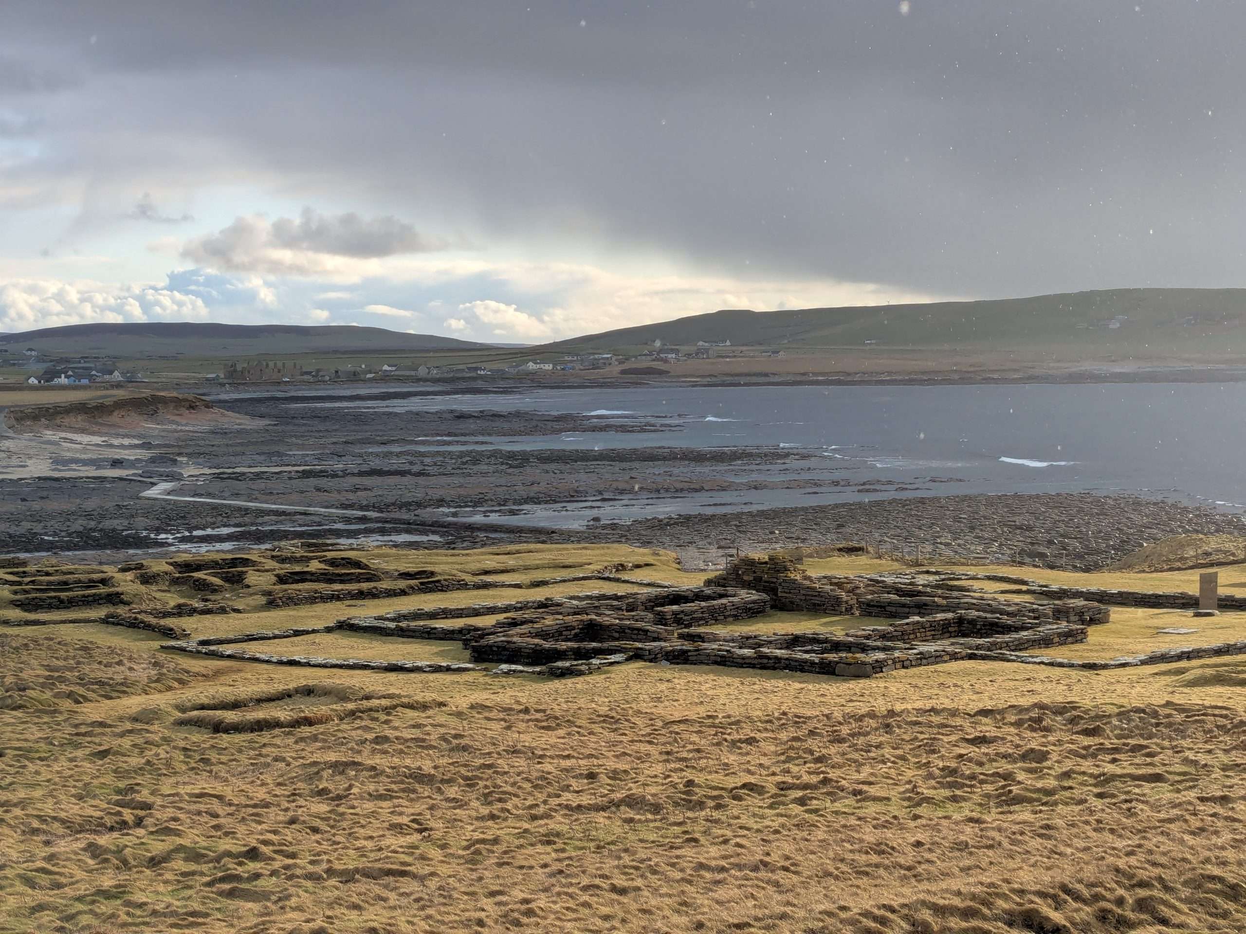
The Broch of Borwick
Orkney has dozens of brochs, stone towers from the Iron Age which, when complete, resembled the cooling towers of modern nuclear power plants. Brochs were certainly defensive in part, with thick stone walls and a towering height advantage, but they were also homes for extended families and even places of worship – several brochs have wells and subterranean passages which were likely used to commune with the ancient gods and the dead.
The Broch of Gurness and Midhowe Broch, both along the Eynhallow Sound, are the most famous and best-preserved of Orkney’s brochs, but few stand in locations as spectacular as the Broch of Borwick in West Mainland. The Norse who gave it its name called it as they saw it – Borwick is derived from Old Norse ‘borg’, meaning ‘fortification’, and ‘vik’, meaning ‘bay’. The broch stands immediately upon the edge, and will no doubt begin to vanish with a few more centuries’ worth of winds and waves chewing away at the cliffs. Excavated in 1881, locals quickly availed of its fine worked stone when in need of repairs and extensions to their field dykes and cottages. The broch was likely built around 500BC and occupied until as late as 700AD. Remarkably, there was once a path carved into the cliff face leading down to a cave evocatively known as ‘Hell’s Mouth’. Combined with extensive Iron Age cultivation terraces found in the grounds in front of the broch, this was clearly a place of strength, prominence, and high status in the landscape, hardly less impressive today than in its heyday.
The Yetnasteen and the ‘Fingersteens’ of Rousay
Much of the Norse legendarium took root in Orkney during the Viking Age. There are the goblin-like trows who stalk hillsides at night and ancestor spirits called Hogboons who guard tombs. Looming largest, literally and figuratively, are stories of giants. Some throw great stones to settle inter-island rivalries, and others have become great stones themselves. The Yetnasteen in the east of Rousay is one of the latter. Its name comes from the Old Norse jotna-steinn, meaning ‘stone of giants’. The Yetnasteen was once a giant but was caught out by the rising sun and turned to stone by its rays. Now, it thirsts for a drink from the nearby Loch of Scockness. At the stroke of midnight on Hogmanay it comes to life, makes its way to the loch in two great strides, takes a drink, and then returns to its position. Those who attempt to see this transformation occur are invariably distracted, fall asleep, or have imbibed too many drams to be believed.
Two boulders in Rousay are said to bear the fingerprints of Cubbie Roo, an infamous giant resident in the island of Wyre derived from a very real Norse strongman, Kolbein Hruga. These boulders, called ‘Fingersteens’ were thrown by Cubbie Roo in anger at other giants. Antiquarian sources are vague as to their location, but on a recent visit I managed to track down two very likely candidates. One, on the slopes above the Knowe of Yarso in Frotoft, bears four incredibly deep and unmistakeable holes as if massive fingers bored into them. Alongside it is another boulder with deep markings which resemble a three-clawed hand. Another boulder in the shore of the Leean in North Rousay has less obvious ‘fingerprints’ but is said to bring disaster to passers-by who do not place a pebble atop it. With my ferry back to the Scottish mainland due to depart in the next few days, you can be sure I added one to the pile!
Text and images: David C. Weinczok.